Start date October 2017, application deadline Friday 6th January 2017. Apply here.
Ever thought of undertaking a PhD? Gareth Williams, Jonathan Roberts and I have a unique opportunity in an exciting PhD project funded through the ENVISION DTP (NERC).
Entitled: Learning from the Landscape: Can the patch dynamics of reef communities guide their conservation and spatial management?, we aim to enhance our understanding of how the spatial dynamics of an engineering species (e.g. marine reef formers) influence their own resilience within space-time. We will fuse complex datasets, obtained from state of the art photogrammetric approaches and laser scanners, within a mathematical framework to better understand how spatial arrangement influences self-persistence. You will use drone mapping to obtain high resolution data of intertidal reefs, and work with an amazing spatial dataset from a tropical coral reef. This is a challenging project, but the training you will gain will open doors that you never believed to be possible. Science is changing, ecology in particular, and employers/Post-doc supervisors are looking for people with data analysis skills of the highest level.
The advert
The very presence of engineering species within a landscape promotes high levels of biodiversity and ecosystem goods/services. However, their loss and degradation is one of the most significant drivers of global biodiversity loss. Most studies overlook the spatial dynamics that drive the persistence of the engineering species themselves.
In this project, we will address key questions in the spatial ecology of engineering species: 1) how much of a species do we need to conserve in order to ensure that it persists in a landscape, and 2) how much do we need to remove in order to eradicate a species (e.g. an invasive)?
Engineering communities are usually persistent, as the processes that act to remove it (i.e. disturbance) are balanced by those that allow it to expand (i.e. recruitment/growth). We can hypothesise that larger patches will experience relatively less removal risk and have greater expansion potential than those that are smaller, thereby growing to dominate the landscape as time progresses. But do larger patches covering a constrained spatial area confer extended benefits to the wider persistence of these species over those smaller and more distributed, and how does the spatial arrangement of patches affect this?
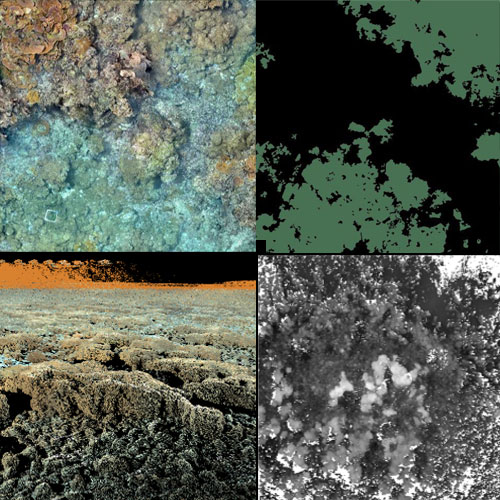
Using high-spatial resolution (sub-cm) multi-annual landscape-scale photo-mosaics, image classification and cellular automata modelling, you will blend ecology and computer science to determine how two model engineering species influence spatio-temporal patterns of their persistence within their landscapes. You will work with data from one of the world’s most remote tropical coral reefs (the Palmyra Atoll) and from spatially dynamic intertidal worm reefs formed by Sabellaria alveolata. This novel project combines computer science, ecology and fieldwork to train you in next-generation data analysis and visualisation. In an increasingly data-driven world, such skills are in high demand across a range of sectors and employers.
More details on the project
The loss and degradation of engineering species within landscapes are significant drivers of biodiversity loss. Yet, most studies overlook the spatial dynamics that drive the persistence of the engineering species themselves. Communities of engineers are spatially and temporally persistent climax communities, whereby the processes that act to remove it (i.e. disturbance) are balanced by those that allow it to expand (i.e. recruitment/growth). Over time they effectively develop into complex patch mosaics with patches of different successional ages and sizes. Within a reef community, we can hypothesise that larger patches will experience relatively less removal risk and have greater expansion potential than those that are smaller, thereby growing to dominate the landscape as time progresses. But do larger patches covering a constrained spatial area confer extended benefits to the wider persistence of these species over those smaller and more distributed, and how does the spatial arrangement of patches affect this? Using high-spatial resolution (sub-cm) multi-annual landscape-scale photo-mosaics, image classification and cellular automata modelling, this multidisciplinary project blends ecology and computer science to determine how two model engineering species influence spatio-temporal patterns of their persistence within their landscapes. Our spatial resolution goes beyond anything that has been attempted before, requiring new image classification approaches, modelling tools and visualisation techniques to be developed. Our findings will directly influence spatial ecology and management across multiple environments, as under certain scenarios, we may be able to promote communities that are of management value by altering patterns, and vice versa, accelerate the eradication of those undesirable.
Specifically, this project will ask:
- Is persistence of an engineering-species dependent upon the size, shape and spatial arrangement of patches within its occupied landscape?
- How does stressor directionality influence spatial arrangement?
- Can patch dynamics be leveraged at small scales to achieve favourable conservation and management impact?
You will utilise two case studies:
- Landscape-scale photomosaic of a Rhodactis howesii invasion on the coral reefs of Palmyra Atoll collated by towed-diver cameras (Funded by US Fish and Wildlife, USFW). The mosaic covers an area of 130x300m, with a resolution of 6mm/pixel, with higher resolution external control sites (10x20m, <1mm/pixel). Data has been collated for 2013 and 2014 and CASE-partner USFW will provide 2016 data later this year.
- Sabellaria alveolata reef photomosaics and 3-dimensional point cloud data from aerial photogrammetry and laser scanner. Multiple surveys have been undertaken, including nine laser scans across 2014, 2015 and 2016 (between 45-79d apart in summer) of an area ~1600m2. Low (2m) and mid-Altitude (20-40m) aerial photomosaics have been collated on an ad hoc basis throughout 2013-2016 (continued work with Orca Principle). The student will collate additional data and conduct experimentation within this site as required.
Rough breakdown of project ideas
Chapter 1 (first 6-months): Undertake a quantitative literature review to compile parameter estimates of key life history traits for each case study species (e.g. growth, spread, decay, settlement), and to estimate those currently unknown from sympatric species, for use in the development of models in Chapter 3. Currently, there are on-going field studies in both systems that will provide additional data, and for Sabellaria, opportunities for fieldwork.
Chapter 2 (Year 1-2): Due to the large spatial extent and high resolutions of both datasets, manual classification is not feasible. The student will develop semi/fully automated classification routines to extract new visualisations of patch size, position and shape from the two datasets.
Chapter 3 (Year 2-3): Develop 2-dimensional cellular automata models for each community, utilising the parameter ranges identified in Chapter 1 to simulate how differently sized patches respond in different spatial arrangements under multiple disturbance scenarios.
Chapter 4 (Year 3): In this chapter we will blend the theoretical model exploration in Chapter 3 with the case-study data from Chapter 4 to inform our understanding of patch dynamics within reef communities and provide operational guidance for conservation and management of these systems.
The criteria
Applicants should hold a minimum of a UK Honours Degree at 2:1 level or above in subjects such as Computer Science, Geography, Landscape Ecology, Mathematics, Statistics or related fields. Some experience in computational approaches and programming is desirable, as is an interest in photogrammetry and remote sensing.
Check your eligibility
Unfortunately, eligibility criteria are strict on NERC DTP’s, check this out here.